Facebook has been working for some time on its project to bring internet connectivity to everyone in the world.
Now the firm has focused its efforts on creating highly detailed population density maps to help understand the best types of connectivity solutions.
The project was carried out by the company’s Connectivity Labs using image recognition technology to produce population maps that are accurate to within 10 metres – a much more precise measurement than previous data sets.
Connectivity Labs is part of Facebook’s Internet.org initiative which aims to bring internet connectivity to the 10% of people who are still currently without it.
The new maps will allow it to determine which connectivity methods, such as Wi-Fi hotspots or cellular connections, will benefit people more.
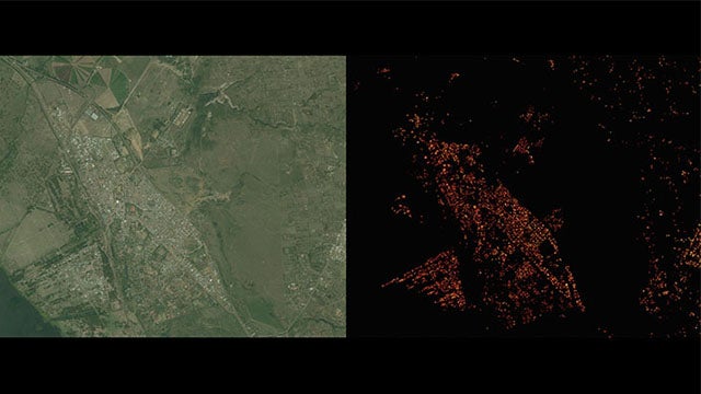
 The previously available data set showing Naivasha in Kenya
Connectivity Labs created the new maps by working with Facebook’s science division, infrastructure unit, and machine learning and artificial intelligence groups.
The group was able to identify human-built structures by analysing satellite imagery for 20 countries and using Facebook’s image recognition engine which is used to recognise faces in photos.
Once the new maps were refined using AI techniques, Facebook was able to use them along with census data to analyse where people live and how they behave, allowing the company to determine the best internet solutions.
The data will be made available later this year when Facebook will partner with Columbia University to create the public data set.

Editorial independence
Editorial independence means being able to give an unbiased verdict about a product or company, with the avoidance of conflicts of interest. To ensure this is possible, every member of the editorial staff follows a clear code of conduct.
Professional conduct
We also expect our journalists to follow clear ethical standards in their work. Our staff members must strive for honesty and accuracy in everything they do. We follow the IPSO Editors’ code of practice to underpin these standards.