Fitness tracking company Strava has responded to criticism after the positioning of active military personnel was revealed by a global heatmap.
The map shows public activities uploaded to the service, with the idea to show where people are exercising.
That means popular exercise routes are revealed, but with many connected devices concentrated in less populated areas, it also inadvertently gives away the geolocations of military bases.
A Twitter user (via Guardian) who raised the alarm said the map made bases “clearly identifiable and mappable” while showing the routes people take while on the move.
This could be a huge security risk, if the publicly-available data was obtained by enemy intelligence.
Strava released their global heatmap. 13 trillion GPS points from their users (turning off data sharing is an option). https://t.co/hA6jcxfBQI … It looks very pretty, but not amazing for Op-Sec. US Bases are clearly identifiable and mappable pic.twitter.com/rBgGnOzasq
— Nathan Ruser (@Nrg8000) January 27, 2018
Strava says the onus is on the public to mark their own data as private, or to create their own privacy zones to ensure sensitive data doesn’t go public.
In a statement, it says: “Our global heatmap represents an aggregated and anonymised view of over a billion activities uploaded to our platform. It excludes activities that have been marked as private and user-defined privacy zones.
“We are committed to helping people better understand our settings to give them control over what they share.
“We take the safety of our community seriously and are committed to working with military and government officials to address sensitive areas that might appear.”
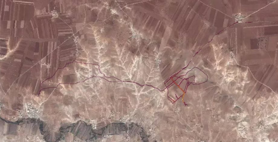
If soldiers use the app like normal people do, by turning it on tracking when they go to do exercise, it could be especially dangerous. This particular track looks like it logs a regular jogging route. I shouldn't be able to establish any Pattern of life info from this far away pic.twitter.com/Rf5mpAKme2
— Nathan Ruser (@Nrg8000) January 27, 2018
In response, the Australian military said it would consider banning the personal fitness devices.
The US Marines already has a policy profiting wearable personal fitness devices “if they contain cellular or wifi, photographic, video capture/recording, microphone, or audio recording capabilities.”
Is this a wake up call for the wearable industry? Or is it up to us to take better control of our privacy settings? Drop us a line @TrustedReviews on Twitter.

Editorial independence
Editorial independence means being able to give an unbiased verdict about a product or company, with the avoidance of conflicts of interest. To ensure this is possible, every member of the editorial staff follows a clear code of conduct.
Professional conduct
We also expect our journalists to follow clear ethical standards in their work. Our staff members must strive for honesty and accuracy in everything they do. We follow the IPSO Editors’ code of practice to underpin these standards.